Studio Joost Grootens
Metropolitan World Atlas
The project
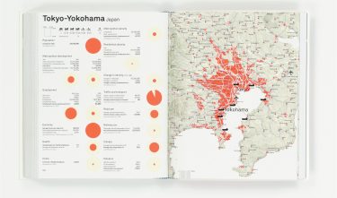
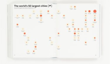
An immense amount of information is made accessible in the Metropolitan World Atlas thanks to the good graphic design. The atlas consists of three sections. There is an overview of relevant global trade networks with league tables of the world’s largest cities, the largest seaports and airports, and telecommunications networks. One of the most remarkable maps concerns the telecommunications network and includes countries such as Russia and China. The map shows that the conurbation of Western Holland plays a key role in the network, and is even ranked third in the world regarding megabits per second.
Committee
The Metropolitan World Atlas stands out through the modern design being a departure from traditional atlases but loses absolutely nothing regarding functionality. A very beautiful and well thought through design.